
")
A state government inquiry into insurance price-gouging in flood mapped areas is on the cards after calls from Logan City Council to investigate potential wrongdoing.
The majority of councillors haev endorsed a plan to hold an inquiry into price gouging by insurance companies for properties affected by low-risk flood mapping.
The move was prompted by widespread backlash over council’s new flood mapping after insurance premium hikes soared into the tens of thousands for many residents.
Cr Scott Bannan said the premium for one resident rose from $3500 to $35,000 since the mapping data was released.
“I’ll go as far as to say that it’s putrid what they’re doing to people,” Cr Bannan said.
“We need to pull the trigger (on an inquiry) as fast as we can.”
Updated mapping was introduced last year under state government orders.
Mapping now considers factors like climate change, isolation and access to critical services to create a risk-based approach.
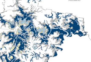
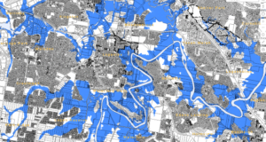
New levels indicating “moderate risk” zones are higher than the previous 1 in 100-year level, with low-risk zones now applying to thousands of properties previously not considered a flood risk.
Cr Jon Raven, the city’s planning chair and the councillor who suggested an inquiry, said council had always known the mapping was a “work in progress”.
“It’s very hard to challenge the data and I don’t think we’re in that space – that data was developed independently and peer-reviewed twice,” Cr Raven said.
“But our policies still need work.”
Cr Raven said there were “anomalies” in the mapping’s flood-risk categories – very low, low, moderate and high – and the land uses allowed in each category, as well as the impacts of high-flow or deep-water floods on residents’ safety.
“What I’m hearing from residents increasingly is the outrage that they have about what the insurance industry is doing to them,” he said.
“Pensioners are being told their premiums will quadruple or that their property just can’t be insured at all.”
Cr Raven said some properties that had a 1 in 2000 annual chance of being flooded – very low risk – had their premiums increased by 400 per cent.
He said insurers were blaming council for the price hike, even though insurance companies were the first to advocate for updated flood-mapping.
Council also voted to support two other motions: a report into council’s flood policy and mapping that includes the concerns of the community, and a letter from the mayor to the Insurance Council of Australia.
Mayor Darren Power was one of the eight councillors to vote in favour of the motions but said he didn’t believe council’s flood mapping caused the premium hikes.
Instead, he blamed extreme weather events throughout the state, specifically in north Queensland, for the sudden rise.
“(The inquiry) will give the opportunity to the insurance companies to respond and if they respond in a way that explains why they’ve done what they’ve done, we’ll be able to pass that onto the residents,” Cr Power said.
“I personally don’t believe the reasons why the premiums have gone up at all relate to the flood mapping.”
