

Tropical cyclones are usually defined as low pressure systems that form over warm, tropical waters. This definition makes them sound almost harmless. But as anyone who has experienced a cyclone knows, it’s far from the case. They’re violent, spiralling wind and rain systems that can wreak havoc at sea and on land. They cause extensive flooding, foreshore erosion, wind damage, and loss of property and life.
How do tropical cyclones form?
Over warm tropical oceans, a cluster of thunderstorms can start rotating around a common centre, due to the earth’s rotation. If the conditions are just right, this process can sustain itself and create a tropical cyclone.
At this stage, the tropical cyclone is like a giant, atmospheric heat engine. The moisture from the warm oceans is its fuel, generating huge amounts of energy.
The rotating thunderstorms form spiral rainbands. Their clouds, circling around the circular eye (centre) of the cyclone where the strongest winds are found, transport heat 15 km or higher into the atmosphere. There, drier cooler air becomes the exhaust gas of the heat engine.
Some of this cool air sinks into the low-pressure region at the centre of the cyclone—the relatively calm eye. The eye is usually about 40 km wide but can range from ten to over 100 km, with light winds and often clear skies. The rest of the cool air spirals outward, away from the cyclone centre, sinking in the regions between the rainbands.
As long as the environmental conditions support this atmospheric heat engine, the tropical cyclone can maintain its structure and even intensify.
Widespread, gale force winds
In a tropical cyclone, gale force winds—sustained winds of 63 km/h or more, with gusts over 90 km/h—can extend for hundreds of kilometres, rotating around the eye of the cyclone.
In severe tropical cyclones, winds exceed 118 km/h with gusts over 165 km/h.
Rising seas lead to storm surges
As well as damaging winds, a tropical cyclone can cause the sea to rise well above normal tide levels when it comes ashore. These storm surges are caused by strong, onshore waves or reduced atmospheric pressure—or both. Potentially, they are the most dangerous hazard associated with a tropical cyclone.
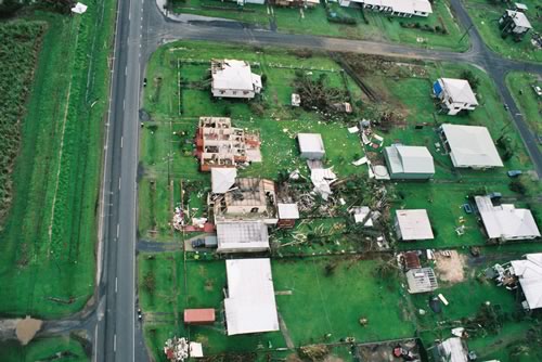
Image: Damage to houses in Innisfail, Queensland, caused by tropical cyclone Larry, March 2006. Credit: Peter Otto
Forming, persisting and weakening
Tropical cyclones can only form when the sea surface temperature is over 26.5 °C. However, once formed, they can persist over lower sea surface temperatures.
They can last for many days, and follow erratic paths. In our region, they can be more erratic than in other parts of the world, moving in any direction, making sharp turns, and even loops.
Tropical cyclones usually weaken over land or colder oceans.
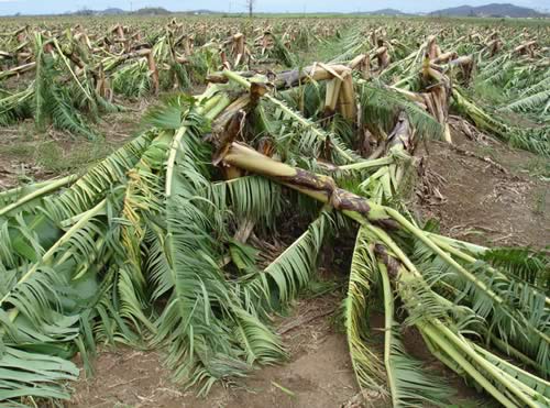
Image: Damaged banana plantation in Innisfail, Queensland, caused by tropical cyclone Larry, March 2006. Credit: Jim Davidson
Tropical cyclones are named to help with communication about these dangerous storms. Names also raise the profile of the cyclone, heightening public awareness and reducing confusion if multiple cyclones occur at the same time. So, how do cyclones get their names?
The Bureau maintains a list of names, arranged alphabetically and alternating between male and female. See the list here.
AskBOM video: How do tropical cyclones get their names?
If a cyclone severely impacts the coast, resulting in significant damage and potentially loss of life (e.g. Larry in 2006 and Tracy in 1974), its name is permanently retired from the list and replaced with another of the same gender and first letter. It can take over ten years from the time a name is put on the list to when it is first used to name a cyclone.
The Australian legacy
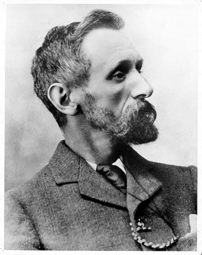
Clement Wragge circa 1900. Image from the Bureau’s archives.
Since the late nineteenth century, tropical cyclones have been receiving names thanks to a colourful and memorable character of early Australian meteorology—Clement Wragge. Nicknamed ‘Inclement’, Wragge left the UK for Australia in 1883, and played an important part in the history of Australian meteorology. He started Queensland’s Central Weather Bureau in 1887, where he was chief meteorologist until 1902. Wragge initiated the naming of weather systems, choosing names ranging from mythological creatures to politicians who annoyed him.
Always included in the historical accounts of naming storm systems, Wragge influenced the naming of powerful weather systems worldwide—from hurricanes to tropical cyclones. The convention of naming Australian tropical cyclones began in 1964 with Bessie, which formed on 6 January 1964 in Western Australia, and was the first Australian cyclone to be officially named. Female names were used exclusively until 1979.
Names used in the Australian region
The first tropical cyclone to form in the Australian region in the 2018–19 season will be named Owen, as per the predetermined list. However, if a cyclone forms in an adjacent region (such as Indonesia) it will be named there, and will keep that name if it moves into the Australian region. A name from the list may be skipped if it is not deemed appropriate when it is due to be used—for example, if it is the same as the name of a public figure who is in the news for a sensitive or controversial reason. A name may also be skipped if a similarly named cyclone is already active in the area.
