
")
Thank you for joining our Wednesday live blog. We’ll be back with Thursday’s live blog from 6am tomorrow. Please join us for all the fact-checked and reliable information you need to get through this weather event.
Join us via this link tomorrow: THURSDAY LIVE BLOG
8.10pm: Emergency Watch and Act for Logan
This just released through police at 8.05pm:
An EMERGENCY ALERT has been issued at 6.53pm on March 5, 2025, by Logan City Council.
TROPICAL CYCLONE WATCH & ACT – PREPARE TO TAKE SHELTER. CITY OF LOGAN will be impacted by Tropical Cyclone ALFRED from Thursday morning.
PREPARE NOW TO TAKE SHELTER. Listen to local radio or visit bom.gov.au for warning updates.
Go to Council’s Emergency Dashboard at disaster.logan.qld.gov.au for more information.
8.08pm: BoM update
One major change: “The centre of alfred is expected to cross the coast during Friday, noting that latest weather model data indicates the potential for a later crossing time than previously indicated.
The cyclone is now 340km east of Brisbane and 340km east northeast of the Gold Coast.
The far western edge continues to impact Coolangatta to Balina.
Predicted wind gusts of 95km/hr to 130km/hr are expected to accompany Alfred as it hits the coast.
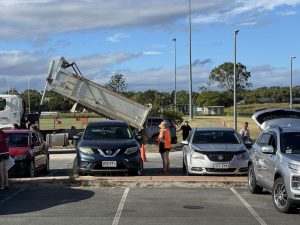
7.50pm: Traffic accident
Albeit not cyclone related, the conditions on the road are getting worse.
Forensic Crash Unit officers are investigating a traffic crash at Hillcrest this afternoon.
Initial investigations indicate around 4.30pm a motorcycle was travelling north on Mount Lindesay Highway when the rider is believed to have lost control and crashed near the Middle Road overpass.
The rider, a 52-year-old man, was transported to the Princess Alexandra Hospital where he remains in a critical condition.
Investigators are appealing for any witnesses or anyone with relevant vision to contact police.
6.51pm: From police …
Important things to remember during a natural disaster
- Follow the instructions of local authorities and emergency services.
- Tune into warnings, remembering that phone and internet services may go down so know your local radio station.
- Locate your severe weather plan and emergency kit and evacuation kit if evacuation is a possibility.
- If you can, put fuel in your vehicle and park it in a sheltered and/or elevated location in case you need to evacuate.
- Check in with family, friends and neighbours.
6.45pm: More closures
Shopping centres are also closing.
Rochedale Village will be closed from 11am tomorrow until further notice “to ensure the safety of our retailers, staff and customers”
Springwood Mall will close from 2pm tomorrow, also until further notice.
And Park Ridge Town Centre will close from 2pm tomorrow, until further notice.
“We are closely monitoring the situation and will provide updates as soon as it is safe to reopen,” management of the three centres said.
“We encourage the community to stay informed through official weather updates and to take necessary precautions during this time. Updates regarding the centre’s reopening will be shared via our social media channels. We appreciate your understanding and urge everyone to stay safe.”
6.35pm: And the roads …
TMR’s view on the roads:
TMR expects impacts to roads and bridges due to flooding and/or high winds. Members of the public should avoid travelling on roads over tomorrow (Thursday) and Friday as it will not be safe due to rain and wind conditions.
Certain roads and bridges may be required to close, depending on conditions. Road users are reminded to drive to conditions. Call 131940 for updates.
“Remember, if it’s flooded, forget it.”
6.30pm: Public Transport
Here are some more details about public transport closures tomorrow and Friday:
Buses will suspend operations after the final service this evening. At this stage there will be no public transport services from tomorrow until further notice.
Queensland Rail: Rail services will be suspended after the last scheduled services this evening. Suspending QR services in a timely manner will enable crews to safely shut down the network.
6.18pm: Closures
The Fo Guang Shan Chung Tian Temple at Underwood Road, Priestdale, has joined a long list of venues closing tomorrow and Friday.
“The temple invites everyone to find peace in the present moment and shelter from the cyclone in the comfort of their homes or with loved ones or friends,” a statement said.
“We look forward to welcoming you back soon and wish everyone safety and well-being.”
5.43pm: BoM update
Two hours on from the last update and Alfred now sits around 305km off the Gold Coast shoreline, and 325km from Brisbane.
He’s slowed a fraction to 14km/hr. The far western edge of the cyclone is starting to reach the coast from about Coolangatta to Balina, and remains category 2.
Bureau analysts predict it will maintain its intensity as it crosses the coast, still thought to be somewhere between Maroochydore and Coolangatta.
In coastal areas, wind gusts could reach between 120km/hr to 155km/hr, but the focus in Logan remains the volume of rain that might come with the cyclone, and the impact that could have on the Albert and Logan Rivers.
5.10pm Council provides places of refuge
Logan City Council is preparing to open an evacuation centre at the Logan Metro Sports and Events Centre from 7.00am on Thursday, 6 March, to assist residents in need of shelter and support.
In addition to the evacuation centre, council has also established temporary ‘drop-in’ places of refuge for those seeking a place to recharge and take a break.
These locations include:
- Jimboomba’s Caddies Community Centre – 9-33 South Street, Jimboomba
- Bethania Community Centre – 88-118 Station Road, Bethania
The temporary refuge centres will offer residents a chance to recharge phones or devices, enjoy a tea or coffee, and rest.
For updates on emergency assistance and other support options, visit the Logan City Council disaster dashboard or follow their official social media channels.
5.00pm: No more sand for Logan Metro Sports Complex
Logan Metro Sports Complex just finished their last load of sand with no more loads coming today.
They will not be open tomorrow.
4.50: Sandbag theft rumours debunked
Reports suggesting that 80,000 sandbags were stolen from the Logan Metro Sports Complex this morning have been proven false.
Council confirmed that the facility started the week with 100,000 sandbags.
As of this morning, 64,000 remained, with another 40,000 arriving at lunchtime.
3.30pm: BoM update
Not much has moved since the last update. Over a couple of hours Alfred has moved about 5km closer to the Gold Coast and Brisbane, despite current movement west northwest at around 16km/hr.
Landfall is still expected to be between Maroochydore and Coolangatta.
It bears repeating that the bureau says absolute worst-case scenario is that Logan could see flood levels similar to 2022. The far more likely scenario is that things won’t get that bad.
3.14pm: Phone tips
Optus provides the following tips for staying connected during a cyclone:
- Make sure your phone is fully charged
- Conserve battery power where necessary by closing all unnecessary apps in the background and placing your phone power saving mode.
- Charge any mobile battery packs for extra back-up charge.
- Back-up your data in the cloud so you don’t lose important personal photos and data.
- Have your emergency phone numbers saved in your phone or written down.
- Connect with a family member or friends outside of the impacted area before a weather event hits, including letting them know what your plans are, and your exact location.
- Know the location of your local evacuation centre and emergency meeting spots along with the different ways to get there if roads are blocked during a disaster.
2.41pm: Caddies activated as emergency refuge centre for Jimboomba
Caddies has been officially activated as the emergency refuge centre for the Jimboomba area.
The facility is now operating 24/7 at the request of the council, offering food, shelter, bathrooms, and showers to residents affected by tropical cyclone Alfred.
Anyone available to assist as a volunteer is encouraged to contact Heath Henwood from Impact Care Services and Caddies on 0411 870 213.
1.42pm: Power
While power outages over the next 48 hours will be determined by the strength of winds, it seems Alfred is the least of Energex’s worries right now. There are currently two outages, both caused by cars crashing into power equipment – one at Chambers Flat, the other at Logan Reserve.
1.25pm: Help us help our city
If you see anything worth reporting, please send photos to media@mycitylogan.com.au. You are our eyes and ears on the ground, and everyone in the city is grateful for your help. The more information we can receive from various parts of the city, the better. Thank you!
1.20pm: Homeless support
Help is available for anyone sleeping rough. There is a homelessness hotline 1800 474 753 and the premier says hundreds of hotel rooms are available for those who need them – already paid up.
1.10pm: Note from the mayor
Mayor Jon Raven says the latest weather bureau advice is that the worst-case flooding scenario is equivalent to 2022.
It is more likely not to be that bad, he says.
The further south the cyclone moves, the better it will be for Logan, given that the southern side is where most wind damage occurs.
He says the main priority is now to clear yards and be prepared for flash flooding. Sand bagging is a great way to ensure water doesn’t get into your homes.
“The safest place to be when the cyclone crosses land is your home,” he says. Therefore, evacuation centres will be open only to those with nowhere to live, or with homes that are unliveable.
Flood mapping is more relevant after the storm has come through and is more likely to occur Sunday or Monday.
We are unlikely to lose water supply, so there is no real need to stock up on water.
The strongest wind will be on coastal areas, not here as an inland city.
1pm: Final sandbag delivery
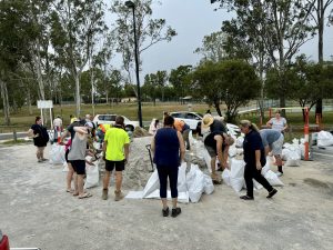
The last load of sand for self-serve sandbags will be delivered to three Logan locations at 6pm tonight.
Residents can access sandbags at:
Beenleigh Showgrounds
Logan Metro Sports Complex
South St, Jimboomba Sports Park
12.30pm:
We’ve just heard that council’s tip stations will be closed tomorrow and Friday.
12pm: Gold Coast emergency alert
Albeit not for Logan, a cyclone watch and act alert has been sent to residents of our neighbouring area, the Gold Coast.
“Significant flooding along waterways is expected to start tonight,” it says.
Those in risk areas have been told to seek shelter by 6pm today.
11.32am: Weather bureau update
The latest weather bureau report has landed. Alfred continues to be a category 2, with winds in the centre of 95km/hr, and gusts up to 130km/hr.
It is 315km off the coast of the Gold Coast and is expected to hit somewhere between Maroochydore and the Gold Coast early Friday morning.
Hazards are intense:
HEAVY TO INTENSE RAINFALL: This is the key watch for Logan, and is forecast for southeast Queensland and northeastern New South Wales from Thursday. This includes the potential for dangerous and life-threatening flash flooding near the cyclone centre and to the south. This is likely Thursday and will probably persist into Friday.
DESTRUCTIVE WIND GUSTS: Up to 155km/hr in coastal areas from tomorrow (Thursday) afternoon.
A DANGEROUS STORM TIDE: Again, coastal. This usually exacerbates any flood conditions.
ABNORMALLY HIGH TIDES: The weather bureau is predicting minor flooding in coastal and low-lying areas.
11.10am: Public transport paused
Public transport will be paused Thursday and Friday. There will be no services for those two days as the cyclone crosses the coast.
11.05am: Schools closed
Schools across Logan will be closed on Thursday and Friday due to severe weather conditions, with public transport services also suspended during this period.
Premier David Crissafulli confirmed the closures at a press conference this morning.
“Schools will be closed in the impacted area on Thursday and Friday,” he said.
“We urge people if they have any questions to visit the Queensland Government disaster dashboard.”
10.28am: Road hazards
They’re not cyclone related, but there are already a couple of hazards on the roads – one reported on the Pacific Highway near Daisy Hill where there’s no blockage, just a warning to take care.
Another is on Chambers Flat Road at Park Ridge which is impacting traffic both ways. Motorists are advised to proceed with caution.
10am: Your trusted source of information
Good morning. As we have done through recent natural disasters, MyCity Logan will be covering all weather event details live. This is your trusted source of news, sifting through the cesspit of misinformation and disinformation that’s being thrown around on social media. Please contact us to send information, videos and photos: media@mycitylogan.com.au.
Everything you read here will be verified through official channels – we’ll tell you what we know when we know it, and we’ll be tapping into our community to ensure we are reporting all the important updates as they happen.
This morning, the premier will have a press conference at 10.30am, and there will be Bureau of Meteorology updates at 11am.

What and where is Caddies?
You need to be much more precise.