
")
It’s now time for flood watch around Logan, head to Saturday’s live blog here.
12.20am: Our coverage
As we have from the beginning, we’ll be with our communities every step of the way, informing everyone with fact-checked reporting.
Our team has more than 40 years’ journalism experience. We live in Logan and we love Logan. MyCity Logan, an independent news organisation, is truly here for you during the good times and the bad.
12.15am: Tomorrow
At daylight, we’ll all be able to assess any damage that has occurred overnight.
Our attention will then turn to the likelihood of flooding. Given the cyclone will land north of us, that means we’re likely to experience the worst of the rain patterns.
The question will be how much rain falls in the catchment, mainly of the Logan River – and for how long. Advice from weather analysts is that rainfall levels are not expected to reach those of the 2022 floods.
There’s every possibility they won’t go close.
However, they are expected to reach major flood levels which means bridges will be cut, roads blocked and suburbs such as Flagstone, Yarrabilba and Jimboomba, among others, isolated.
Mayor Jon Raven said last night that Logan City Council was preparing for that exact scenario. Some areas, he said, might be blocked off for 2-3 days.
12.06am: Good morning
Alfred has picked up speed over the last hour, and now sits just 55km east of Brisbane.
For Logan, that means it will start to move northwest and wind strength should decrease. The rain unfortunately, will likely stay.
According to latest weather reports, despite the cyclone being downgraded to a Category 1, damaging wind gusts could continue well into the morning and through tomorrow.
Winds of 85km/hr with gusts up to 120km/hr remain around the fringes of the eye of the cyclone.
11.47pm: Outages
We can add 1600 homes in Bethania and more than 200 in Carbrook to the list of those without power.
For those without power, Energex said earlier today it would wait for damaging winds to subside before sending crews into the field. They did say however, that they had brought in extra crew members to help with the expected high demand for repairs.
11.44pm: The wind
The wind maps we’re looking at show the gusts most of us are experiencing right now are anywhere between 30km-60km/hr.
Winds to the south of the eye of the cyclone are by far the strongest.
11.30pm: The visual
The tracking map shows the jelly bean has disappeared. While there are still cyclonic winds 65km east of Brisbane, and high wind gusts throughout the southeasts, particularly along the coast, the downgrade shows lower risk of destruction.
As the map shows, the gale force winds have yet to hit Brisbane, but they are currently in eastern suburbs from Beenleigh through to Cornubia, Longanholme, Daisy Hill and Springwood.
If power is out, there’s every chance trees are down, although we can’t confirm that. If that’s the case, please stay away from anything that looks remotely like fallen power lines.
![]()
11.25pm: Very destructive winds not a threat
The latest tracking map shows the jellybean has gone, which means there are no longer destructive or very destructive winds.
There will however, in most areas, continue to be gale force winds over at least the next few hours, and likely until morning.
85km/hr winds are still strong and can do significant damage.
11.19pm: Power outages
The wind we are getting is doing exactly as expected – more than 2000 homes across the city are without power, the majority of those in the eastern suburbs of the city.
Those include – more than 1200 homes in Cornubia, 400 in Daisy Hill, and more than 360 at Loganholme.
There are also almost 500 homes without power at Greenbank.
11.12pm: Cyclone weakens to Category 1
Even though there are some pretty big winds outside, there’s some good news from the weather bureau.
As expected as the worst of hit starts to hit landfall, the ferocity of Alfred is already starting to weaken. In its latest report, speeds in the centre are now 85km/hr, which reduced the cyclone to a Category 1.
It has also gathered some speed, to 9km/hr. The less time it takes to pass, the less rain and flooding.
This is the bureau’s official word: Tropical Cyclone Alfred, category 1, is most likely to cross over the Moreton Bay Islands early Saturday morning before crossing the mainland coast, between Maroochydore and Brisbane towards the middle of the day. Alfred will weaken as it moves inland late Saturday and Sunday.
10.52pm: Wind maps
Wind maps show that winds up to 90km/hr are already hitting the coast moving towards Redlands. And there are some heavy gusts being reported in some areas of Logan, according to wind maps above 50km/hr.
10.23pm: Flood levels
It’s worth noting that the most recent flood levels were sent through by the Bureau of Meteorology at 5.23pm. The next update is expected to come through at around 5am.
10.17pm: Tracker
As expected, the tracker shows the jellybean moving along the coast in the early hours of the morning, in particular the Redlands and Bayside suburbs, towards Redcliffe which is where some weather tracking analysts feel the eye of the cyclone might pass.
Whether those winds reach Logan’s eastern suburbs in their travels is yet unknown.
10.05pm: BoM update
Not a lot has changed over the past hour. The cyclone is 5km closer to Brisbane and is still headed towards the Moreton Bay Islands at 7km/hr, before crossing land somewhere north of Brisbane tomorrow morning.
The key to Logan’s likely impact sits with the tracking map which is set to be release within minutes. It will show us where the jellybean sits (see 6.50pm post) and the destructive winds that come with it.
It bears repeating what the mayor said this evening, that Logan suburbs on the eastern side of the M1 stand to wear more of the brunt of strong winds than those on the other side of the highway.
This is because those to the west are more protected. The further west, the more protection there is.
Alfred is expected to weaken as it moves inland late Saturday and Sunday.
9.15pm: Tracker
As the tracker shows, we’re far from being out of the woods yet, but indications at this stage are that we’ll be in for gale force winds, and potentially the southern tip of destructive winds which is what we’re all happy not to see.
The worst of it could be between 3am-9am.
![]()
The issue with this for Logan is that the cyclone will pass to the north of us, and the majority of rain is to the south.
Some media reports are predicting up to 800mm of rain, albeit in coastal areas. The best case scenario is for the storm to fizzle out soon after landfall, reducing the overall volume of rain into the catchment of the Albert and Logan rivers which are both rising tonight.
9pm: BoM update
We can expect that the next couple of hours will tell a big story for Logan and how we can expect the night to unfold.
And already we’re seeing things change.
The 9pm report has narrowed the area where the cyclone is expected to make landfall, now between Brisbane and Maroochydore (previously Noosa to Beenleigh). And importantly, the destructive winds to the south of the eye are also likely to miss Logan.
We will still likely see galeforce gusts of wind, so it is worth remaining vigilant.
And we are constantly being warned. Cyclones can be fickle, and can change direction quickly.
Winds remain strong at 95km/hr at the core. It now sits 80km east of Bristane, travelling west northwest at 6km/hr.
Here’s the critical bit: “Tropical Cyclone Alfred, category 2, is most likely to cross over the Moreton Bay Islands Saturday morning before crossing the mainland coast, between Maroochydore and Brisbane later during the day. Alfred is expected to weaken as it moves inland late Saturday and Sunday.”
8.46pm: Sandbag fact
In the lead up to this weather event, more than 250,000 sandbags have gone out to the community. That’s a huge amount of work, much of it done by volunteers.
8.38pm: Power outages
There are about 50 houses without power, at Belivah, Jimboomba, Logan Village and Wolffdene, mostly due to wind damage.
8.20pm: Roads
Just a couple of hazards so far: Centurion Circuit at Holmview is cut off, and there’s a hazard on Tamborine Rd at Logan Village, with drivers asked to proceed with caution.
8.15pm: Rainfall
Some heavier rainfall starting to hit from Logan Central to Beenleigh, up around 10mm-15mm per hour according to the radar. Lighter rain is to the west.
8pm: BoM update
Alfred is now just 85km from Brisbane, directly east, and now moving west northwest at 7km/hr.
Winds remain 95km/hr at the centre.
Rain is starting to fall heavier in Logan as the intensive wind and rain to the south of the cyclone makes its way to the mainland.
Landfall predictions have not changed, despite seeming to move further north.
7.26pm: From Optus
As at 5pm (AEST) 52 mobile sites have lost connection due to power failures in the impacted regions.
The safety and wellbeing of our customers and employees are of the utmost importance as we work as quickly as possible to restore services.
Customers may be able to use Optus Wi-Fi calling or apps like WhatsApp and FaceTime to make calls where Wi-Fi is available. This feature needs to be enabled in the phone’s settings.
Emergency calls to Triple Zero on mobile networks during power outages should work if another carrier is available.
Fixed and mobile generators are being deployed, SatCats are positioned in Brisbane and Coffs Harbour and extra personnel from interstate have been called in to add additional support.
At this stage, we don’t know how long it will take to resolve services, but we are prioritising our resources to address impacted areas.
7.15pm: BoM update
We’ll keep this one simple. The cyclone has slowed to 6km/hr, and the trajectory remains the same. In the past hour, the cyclone has moved only 5km, but is just 95km from Brisbane.
The eye of the cyclone is still likely to cross the mainland between Noosa and Beenleigh, however we can expect high wind gusts overnight in Logan due to the jellybean theory you see in the 6.50pm post.
The intensity of the cyclone remains at 95km/hr with gusts to 140km/hr.
7.10pm: North or south?
There seems to be two schools of thought on what might happen to Alfred when he hits the shore – the more popular option seems to be that the cyclone will head towards Redcliffe and drift north.
However, there is a second theory that it may bump the shoreline and drift south.
Such is the unpredictability of what we are dealing with. As far as Logan goes, the quicker it turns south, the better off we are likely to be.
7pm: Stay at home advice
People on the coast have already received notifications to stay at home. Logan hasn’t received that advice as yet, but we can expect an alert tonight at some point.
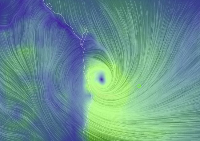
6.50pm: More information
We will get at least 24 hours’ notice of flooding. Cr Raven suggests everybody look at 2022 levels as a good reference point – we’re unlikely to reach those levels, he says.
Cr Raven explained that we would receive high winds, and gave a terrific lesson on the red jellybean in the tracking map.
![]()
1. The blue number 2 shows the likely track of the eye of the cyclone.
2. The jellybean is where all the rain and wind is, and that’s headed directly for Logan.
3. While it would be bad for northern NSW, it would be best for Logan if the red jellybean headed south because it would mean less wind and rain.
4. On its current trajectory, the red jellybean will impact most of Logan BEFORE the eye of the cyclone hits land.
Cr Raven says we have had high winds before, but not this bad. He says stay at home, and be safe.
6.47pm: Mayor’s report
Mayor Jon Raven says suburbs east of the M1 are far more likely to experience high wind – Springwood, Daisy Hill, Loganholme, Cornubia – than those on the other side of the highway.
The more west you go, the more shelter there will be.
He says people should from now remain in their homes.
6.13pm: Mayor live stream
Mayor Jon Raven is scheduled to start his live stream on Facebook at 6.15pm. We’ll summarise what he has to say.
6.05pm: Flood warning update
The Albert River is being spared major flood risk status. This is good for a number of reasons – not least that anybody impacted by flooding in that area is likely to be spared major flood levels.
But it also means the convergence of the Logan and Albert rivers is not at the level of 2022.
The Logan River however, has a major flood warning against it, with levels expected to rise from late tomorrow (Saturday).
Major flooding may occur along the Logan River to Yarrahappini.
The Logan River at Beaudesert is currently at 3.77 metres and rising, below the minor flood level (5.50 m). The Logan River at Beaudesert is likely to exceed the minor flood level (5.50 m) Friday evening. The river level may exceed the moderate flood level (7.80 m) and major flood level (8.30 m) from Saturday morning. Further rises are possible with forecast rainfall.
This from the bureau:
The Logan River at Maclean Bridge is currently at 2.79m and rising, below the minor flood level (10m). The Logan River at Maclean Bridge may exceed the minor flood level (10m) Saturday evening. The river level may exceed the moderate flood level (13.50 m) overnight Saturday into Sunday. Further rises are possible with forecast rainfall.
The Logan River at Waterford is currently at 1.1m and rising with the tide, below the minor flood level (6m). River level rises are likely from Saturday, and minor to moderate flooding may occur along the Logan River at Waterford during Sunday, with further rises possible.
The Logan River at Parklands is currently at 0.69 metres and rising with the tide, below the minor flood level (2.5m). River level rises are likely from Saturday, and minor to moderate flooding may occur along the Logan River at Parklands during Sunday, with further rises possible.
The Albert River at Wolffdene is currently at 1.90m and steady, below the minor flood level (6m). The Albert River at Wolffdene is likely to exceed the minor flood level (6m) Saturday afternoon. The river level may exceed the moderate flood level (8m) Saturday evening. Further rises are possible with forecast rainfall.
The Albert River at Beenleigh is currently at 0.67m and falling with the tide, below the minor flood level 3.5m). River level rises are likely from Saturday, and minor to moderate flooding may occur along the Albert River at Beenleigh overnight Saturday and into Sunday. Further rises are possible with forecast rainfall.
5.56pm: BoM update
If you believe in milestones, Alfred is within 100km of Brisbane, currently east southeast, and 75km east northeast of the Gold Coast.
Still 7km/hr, and still expected to cross land tomorrow morning over the Moreton Bay Islands. The predicted land crossing area remains to be between Noosa and Beenleigh – nothing more specific than that as yet from the Bureau analysts.
5.55pm: Lighthouse Appeal
Lighthouse Care is a well-known charity in Logan, and its leader Debbie is organising a disaster relief appeal.
Find it here: https://www.facebook.com/share/1EMNLJAQVf/
5.39pm: Rural concerns
The National Rural Health Alliance (NRHA) is deeply concerned for the health and wellbeing of rural communities as Cyclone Alfred, expected to be the worst weather event in 70 years, makes landfall later today or tomorrow in NSW and Queensland.
“We are particularly concerned for the people in rural southern Queensland and northern NSW, who are already facing immense healthcare accessibility challenges,” said Susi Tegen, NRHA Chief Executive.
“We urge all residents in these areas to exercise caution, continue to take necessary measures to prepare, and stay resilient as they face the aftermath of this powerful storm.”
5.33pm: Thank you
Before things get too hectic, thanks to all those who have sent kind words to our email media@mycitylogan.com.au.
At MyCity Media (you’ll have seen MyCity Logan, our weekly newspaper and three monthly Suburban Life magazines), we maintain the same ethos year-round – to keep Logan informed about local events, large and small. We live in our community and we love our community. We’ll always stand by our community.
5.24pm: Wind image
This image from the earth.nullschool.net website – frightening, but impressive all the same. What it shows is that the real winds haven’t yet intensified beyond the coastline.
5.17pm: Power outages
A few more power outages at Jimboomba and Logan Village. All wind-related. About 40 houses impacted in total.
5.06pm: Rainfall
Heavy rainfall bands are continuing to develop.
From the Bureau of Meteorology: “Heavy to locally intense rainfall which may lead to dangerous and life-threatening flash flooding is likely to develop this evening and increase into Saturday.”
Once Alfred crosses the coast, it will likely weaken below cyclone strength. But it’s the rainfall we want to see dissipate. Flood warnings remain in place for the Albert and Logan rivers – particularly the Logan river from Beaudesert through to our own suburbs.
5.03pm: BoM update
Alfred is still slow, at 7km/hr, and still likely to cross the coast tomorrow. But bureau chiefs are warning that the wind gusts could start any time tonight. As could the heavier rain.
In the latest report, the winds at the centre of the cyclone have weakened slightly, to 95km/hr, but gusts are still expected up to 140km/hr in coastal areas.
Still expected to cross somewhere between Noosa and Beenleigh.
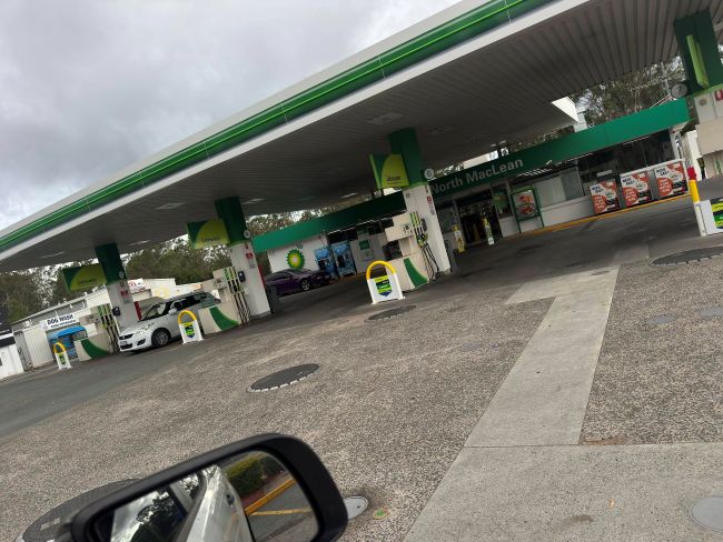
4.55pm: Out of gas
BP North Maclean is officially out of unleaded fuel.
4.45pm: City of champions
The city is full of champions through times like these. Beenleigh’s Matthew Lloyd was out most of the day delivering sandbags to those who couldn’t do it themselves.

4.40pm: Sirens will sound
For those who haven’t been in a cyclone before, you’ll hear sirens on TV and radio which will be to alert coastal areas of destructive winds.
Those sirens won’t be meant for us in Logan.
From the mayor Jon Raven: “Coastal areas are expecting winds of more than 100km/hr. Logan – particularly the areas on the eastern side of the city and around the M1 – will still experience strong winds, but not as severe as the coast, later tonight.”
“Western areas like Park Ridge and Browns Plains are a bit more sheltered from the winds than the east of Logan. Heavy rain still to come though.”
4.35pm: Buying my new mate a beer
Cr Scott Bannan posted this less than an hour ago: This poor bugger, arrives from Canada on Tuesday and gets welcomed by a Cyclone then has to help shovel 70 cube of sand today. Least I could do was buy him a beer.”

4.30pm: BoM update
115km from Brisbane, 90km from the Gold Coast. Things are getting real now. Alfred continues to move at around 7km/hr, and winds remain at around 100km/hr at its centre, with wind gusts of up to 140km/hr.
There is no change in direction – crossing the mainland somewhere between Noosa and Beenleigh.
3.24pm: River levels
Everything is okay for now, with the river heights below those required to trigger minor flooding.
Authorities are saying however, that this will change. Catchment areas are seeing plenty of rain, and they are likely to be impacted by the intense rainfall near the centre of the cyclone as it crosses the coast – regardless of whether it remains a cyclone or becomes a tropical storm.
3.19pm: BoM update
Reports are coming through hourly now, indicating that things are getting more serious.
Alfred now sits just 120km east southeast of Brisbane and 85km east northeast of the Gold Coast.
And it’s best we quote BoM directly on this one: Alfred is most likely to cross over the Moreton Bay Islands Saturday morning before crossing the mainland coast, most likely between Noosa and Beenleigh later during Saturday.
1.28pm: BoM update
Alfred is most likely to cross over the Moreton Bay Islands Saturday morning before crossing the mainland coast, most likely between Noosa and Beenleigh later during Saturday.
That’s the latest word from the Bureau of Meteorology, meaning we all have to wait some more, until this whole thing is over.
The bad news is that winds at the centre of the cyclone are still around 100km/hr with gusts up to 140km/hr.
Worse news for Logan is that the longer the cyclone lingers off the coast, the more rain is likely to fall into our catchments.
There is already a flood warning for the Albert and Logan rivers.
BoM is increasing the frequency of its warnings. They are now being released almost hourly, so we’ll be sure to notify everyone of changes as they arrive.
1.08pm: Queensland Health services
Queensland Health is reminding residents to plan for medical assistance if they are unable to leave home during severe weather.
The Virtual Emergency Care Service is available 24/7 here or by calling 13 43 25 for remote medical support.
Additionally, 13 HEALTH (13 43 25 84) remains open around the clock for health advice.
12:56pm: Animal hospitals closed
Park Ridge Animal Hospital and Browns Plains Veterinary Surgery will remain closed on Saturday and Sunday.
They both plan to reopen on Monday morning.
12.27pm: Daisy Hill refuge
Slacks Creek Rugby League on Rose St in Daisy Hill is offering a 24/7 place of refuge.
Similar to other refuge centres in the area, tea, coffee and shelter will be available.
No bedding.
11.46am: Up to $1 million for Logan clean up
Logan City Council will be able to dip into a $15 million emergency fund available to local authorities in Alfred’s impact zone.
It’s a joint federal/state government package that provides councils up to $1 million for immediate clean up and restoration.
Councils can use this funding for waste and debris removal from streets, properties, and community assets, and activities to restore public assets.
“In the wake of such devastation, it’s crucial affected communities know we have their back,” prime minister Anthony Albanese said.
Premier David Crisafulli said: “Just as work continues in the north and far north, we’ll walk side by side with local governments during the next phase of recovery.”
11.23am: Power outages
Not too many outages around the city right now. About 30 due to wind-related damage at Jimboomba and Logan Village, and about 10 under investigation at New Beith and Greenbank.
11.11am: Noisy generators
Some people have expressed concern about noisy generators.
“Just be considerate of your neighbours and turn them off to allow them to sleep,” mayor Jon Raven said. “Those with generators for medical devices are not an issue.”
11.05am: Sandbags still available
Mayor Jon Raven says sand is still available at Jimboomba and Logan Metro. However, people are being urged to take their own bags.
Council tips will be open after the storm, enabling people to dispose of their rubbish, depending on the severity of damage.
Cr Raven urged caution when clearing fallen trees, particularly due to the risk of live power lines.
Garbage collection is expected to resume Monday.
11.02am: Safe parking not so safe
People are being warned that parking their cars in undercover parking areas such as Logan Hyperdome isn’t a good idea.
Logan Hyperdome has closed its undercover parking area due to the risk of flash flooding.
10.54am: More from BoM
Destructive wind gusts: Exposed coastal locations at the Gold Coast and Moreton Bay islands could see 155km/hr winds. Damaging wind gusts of 120km/hr are more likely in the inland and near-coastal areas from Cape Moreton to Yamba – a long stretch.
These winds, on and off, will probably start later today and continue most of tomorrow.
Heavy rain: Bands are continuing to extend over southeast Queensland, and they are hitting the catchment areas of the Logan and Albert rivers. Intense rainfall will continue near and south of the system – which puts Logan in the firing line for flash flooding.
A flood warning is in place for our city.
10.39am: BoM update – Beenleigh named as landfall possibility
Cyclone speed is picking up a little, now 8km/hr and about 160km east of Brisbane, 135km east northeast of the Gold Coast.
An important update to the likely path: “Alfred, category 2, is most likely to cross over the Moreton Bay islands Saturday morning before crossing the mainland coast, most likely between Noosa and Beenleigh during Saturday.”
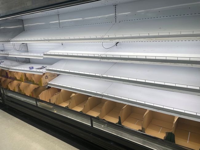
9.55am: Supermarket sellout
This is where the eggs normally hang out at Woollies (Holmview):
9.48am: Help for Community Centre
9.34am: Some sandbags still available
There are limited filled sandbags at Jimboomba Sports Park and Logan Metro Sports Complex.
There is also still some sand available at those locations, but you will need to source your own bag.
9.03am: More shops open
Chatswood Central will be open today, with Woolworths open from 8.30am – 12pm. Holmview also open, along with the adjacent cafe.
Centre management says to check directly with other speciality stores in the centre for their trading hours.
8.34am: BoM update
It would seem Alfred’s on the move again, slowly at around 6km/hr. Winds at the core have intensified to around 100km/hr, with gusts up to 140km/hr.
These winds are not expected to be as destructive by the time the storm cell reaches Logan, however weather forecasters are expecting gusts in higher areas throughout Saturday.
The cyclone is now 165km east of Brisbane, 140km east northeast of the Gold Coast.
Although the rain has died down this morning in Logan, the bureau is reporting heavy rainfall bands throughout southeast Queensland, so we can expect the rain to pick up later today.
A flood watch is current, so all eyes are now on catchment areas to see how much rain is falling into the Albert and Logan rivers.
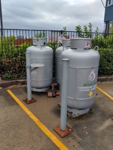
8.32am: Gas refills
If you need your gas tanks filled, Browns Plains Home Hardware has gas available and will be open this morning.
Located at 65 Grand Plaza Drive, Browns Plains.
8.21am: Check your water grates
A tip from councillor Paul Jackson to make sure to clear any debris or blockages from stormwater drains before the rain hits, if it is safe to do so.
“Our stormwater system is built to handle up to 150mm of rain per day, but anything above that can cause overland flows from neighbouring properties and streets,” Cr Jackson said.
“Use objects like sandbags to divert flowing water away from your house and ensure gutters and downpipes are clear.”
7.47am: Power outages
Wind damage has a few houses without power – a couple at Jimboomba and around 25 houses at Logan Village.
7.39am: Useful app
The Logan Early Warning app provides key features including:
- alerts based on your registered residential address
- alerts from across Australia based on your GPS location
- a ‘Help Me’ feature that sends your location and details to nominated email addresses and contact numbers
- a feature that lets you call Emergency 000, SES 132 500, Police 131 444, and a 24-hour GP while providing your GPS coordinates and estimated address
- access to weather radar information based on your location
- location display
7.13am: Who’s open?
Quite a few cafes around the city remain open, including all Zarraffas stores until 12pm.
HQ Espresso at Jimboomba is open.
A number of supermarkets are also open – Woolworths Park Ridge is confirmed (until 5pm), as is the one at Marsden on 5th (until 3pm), Meadowbrook (until 3pm) and Jimboomba (until 11am).
Most Coles stores are opening this morning.
Know more? Email media@mycitylogan.com.au so we can include it.
7.13am: Business tips
Here are some tips from the Logan Chamber of Commerce:
6.50am: In perspective
If there is any good news to be gleaned from the flooding predictions, it’s that they are well below the peaks of the 2022 floods that inundated the city.
During that time, the Logan River at Maclean Bridge peaked well above the major flood level of 16m, reaching 20.5m on February 28. This was well the 2017 level of 23.97m.
On that occasion between 420mm and 880mm of rain (at various points) fell into the Logan and Albert River catchments in a week.
In 2022, 263 homes flooded across low-lying suburbs including Waterford, Chambers Flat, Beenleigh and Bethania. The worst of those have since been removed, bought back by government, or developed to higher flood-proof standards.
6.40am: River levels
The Logan River at Beaudesert is currently at 1.77m and rising, albeit still well below the minor flood level of 5.5m.
According to the weather bureau: “The Logan River at Beaudesert may exceed the minor flood level (5.50 m) Friday afternoon. The river level may exceed the moderate flood level (7.80 m) Friday evening and may exceed the major flood level (8.30 m) late Friday, with forecast rainfall.
“The Logan River at Waterford is currently at 1.5m and rising with the tide, below the minor flood level (6m). River level rises are likely from Friday, and minor to moderate flooding is likely at the Logan River at Waterford during Sunday, with further rises possible.
“The Logan River at Parklands is currently at 1.29m and rising, with the tide, below the minor flood level (2.5m). River level rises are likely from Friday, and minor to moderate flooding is likely at the Logan River at Parklands during Sunday, with further rises possible.
“The Albert River at Wolffdene is currently at 1.7m and rising, below the minor flood level (6m). River level rises are expected from Friday, and minor to moderate (8m) flooding is likely along the Albert River at Wolffdene during Saturday. Further rises are possible with forecast rainfall.
“The Albert River at Beenleigh is currently at 1.42m and rising with the tide, below the minor flood level 3.5m). River level rises are likely from Friday, and minor to moderate flooding is likely at the Albert River at Beenleigh during Saturday, with further rises possible.”
6.30am: Flooding
Another significant update early this morning has been to the flood warnings, issued for the Logan and Albert Rivers.
With moderate to heavy rainfall in the catchment areas yesterday, and further forecast rainfall, moderate to major flooding is possible today.
Flooding is likely to develop further downstream from later Friday into Saturday.
And here’s the concern: “Forecast heavy to intense rainfall has the potential to cause dangerous and rapid river level rises along the Logan and Albert rivers and its tributaries. Major flooding is possible from late Friday with forecast rainfall, and further rises are possible over the next several days.”
6.20am: Winds
For Logan and surrounds from the weather bureau: “Although Alfred is expected to cross the coast and move inland during Saturday, damaging wind gusts may continue, particularly over elevated terrain for most of Saturday. Winds are expected to ease overnight on Saturday.”

6.05am: BoM update
Hello everyone. We’ve been scouring the information available to us overnight, and there are a couple of significant developments in weather bureau predictions.
One is the point of landfall. The bureau has been reluctant until now to predict a precise point of landfall for Alfred, however it is now “most likely” to cross close to Moreton Bay, albeit still with a possibility between Noosa and Coolangatta.
The other development is that the movement of Alfred has slowed to a near halt. Yesterday, it was moving anywhere between 7km/hr to 14km/hr. The bureau’s latest advice is simply “slow moving”.
6am: We’ll be here for the duration, providing Logan with everything you need to know about Alfred, the impact, and the aftermath.
Join us throughout the day to be informed and aware of everything going on around your neighbourhood. We care about our city.
